GIS Integration For Your Control Room
In some cases, it is important to know exactly where a critical event is taking place. Our GIS integration makes use of the latest geolocation features.
What are GIS integrations?
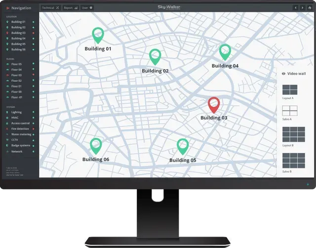
Skywalker GIS integration allows for a very intuitive visualization of mobile units and alarms through the GIS integration module and allows the operator to have a global view of the situation's progress via integrated mapping in the user interface.
The user interface with GIS mapping helps the operator to make faster decisions. As soon as an alarm is triggered, it is possible to see within seconds where the incident is occurring. This tool, updated in real time, comes in particularly handy when companies are spread over several locations. They can all be monitored from a central control room with several workstations.
Each workstation in the control room can be equipped with a gis map. If one of the operators is busy, another can see the progress of the situation in real time!

Sky-Walker GIS integrations on multisite location
Monitor your mobile teams with GIS
During an incident, one or more mobile teams may be assigned to an intervention and it is the operators who do this.
In the control room, each operator using the hypervision software follows the actions of the mobile teams thanks to the geolocation of the mobile teams. The operator(s) can also check the concordance of the operations performed by the mobile teams with the video wall! Indeed, the integration gis can be connected to the cameras of the buildings but especially to the cameras where the incident occurred.

Control room with security operators
Interested in a PSIM Software demo?
Good news! Our sales team can't wait to give you a live demo experience of our PSIM software Sky-Walker.
Advantages of using Sky-Walker GIS Integration
Real-time updates
GIS integration allows your organization to obtain real-time information and location updates from all your mobile teams. This makes the entire handling process more efficient.
Save costs
Because route planning is optimally calculated through GIS integration, your transportation costs can be greatly reduced. Moreover, our GIS integration ensures that you will reach your business goals faster.
Manage your incidents efficiently with our Incident Manager
With our Incident Manager, you can create procedures for the follow-up and handling of an incident.


 Download Product Ebook
 View all our solutions
 Sky-Walker Architecture
 View all our integrations
 Book Protocol workshop
 Our Company
 Contact Us
 View All Our Case Studies
 Become a PSIM Partner
 Become a Sky-Walker PSIM partner today!
 English
 Français
 Nederlands